


|
|
|
|
|
|
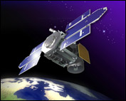 |
Geoscience Laser Altimeter System (GLAS) is a laser altimeter that will fly on the Ice, Cloud and land Elevation Satellite (ICESat). |
| GLAS is designed to measure the height of the ice caps with an accuracy of about one inch. It takes 40 measurements/second, and will operate continuously over its three-year life. GLAS will fire a four-nanosecond laser pulse to the Earth's surface, and measure the round-trip travel time of the reflected light. (The stopwatch on GLAS must be accurate to one-tenth of a billionth of a second.) The round-trip travel time will be used to calculate the distance from the satellite down to the ice. The long-term variation in ice thickness is obtained by subtracting the distance to the ice from the Global Positioning System's precise fix on the satellite's location above the Earth. ICESat's measurements will help determine the mass balance of the polar ice sheets and their contributions to global sea levels, establishing a baseline on ice balance to determine how significant greenhouse warming may be. The instrument will also make measurements of cloud heights and their vertical structure, atmospheric aerosols, and land surfaces. GLAS uses a diode-pumped Q-switched Nd:YAG laser with energy levels of 75 mJ and 35 mJ. Three lasers will be flown, one active and two spare, to assure mission lifetime performance. NASA's Goddard Space Flight Center led the development of the GLAS instrument. Ball Aerospace developed the carrier spacecraft, a BCP 2000 bus. ICESat launched in January 2003 on a Delta II rocket. |
|
| Copyright ©2004 by Ball Aerospace & Technologies Corp. |